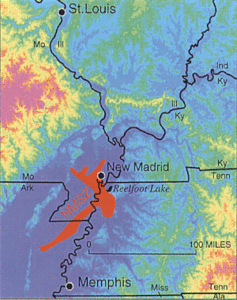
A couple of weeks ago, I shared The Legend of Reelfoot Lake. Here are the historical facts about the earthquakes in that legend.
Timeline
(All times listed are local to where the quakes occurred.)
December 16, 1811, 2:15 A.M. – The first quake (7.2-8.2) hit what is now Northeast Arkansas.
December 16, 1811, 8:15 A.M. – 7.0 aftershock.
December 17, 1811, Midnight – 7.0 aftershock.
January 23, 1812, 9:00 A.M. – A second major quake (7.0-8.0) hit what is known today as Missouri’s “Bootheel.” It’s theorized that this earthquake, a rupture of the New Madrid fault, put strain on the Reelfoot fault.
February 3, 1812, 3:45 A.M. – A third major quake (7.4-8.6) hit near the Mississippi River town of New Madrid. (Today the town is in Missouri, but at the time of the earthquakes, it was in the Louisiana Territory.) This quake destroyed the town of New Madrid and formed Reelfoot Lake.
February 3, 1812, 10:40 P.M. – 7.0 aftershock.
The Impact
While the earthquakes listed above were the most notable, a multitude of smaller but still significant ones continuously shook the area from December 16, 1811, through February of 1812…and beyond. (In fact, in 1813, hundreds of smaller aftershocks were still occurring.)
Although at the time of the earthquakes few European settlers lived in the area, there were some. Here’s one eyewitness’ description:
“Great fissures opened the earth, geysers show mud and rocks hundreds of feet in the air, new hills and ridges heaved up out of the ground, and the river itself ran red with brimstone and sulfur. Whole islands in the river disappeared, the forests went under, the tall oaks snapped like twigs, and violent winds tossed bundles of fallen timbers. Deafening thunder rang to the heavens. Animals went crazy; thousands of birds hovered and screamed.”1
Even with the eyewitness accounts, it’s hard to imagine the sounds, smells, and sights that accompanied these earthquakes. And to experience it over such a long period of time had to be devastating, living in constant fear of another major quake. I wonder how many weeks and months (or even years) went by before the fear receded, and the people living in Missouri, Arkansas, Mississippi, Alabama, Tennessee, Kentucky, Illinois, and Indiana managed to return to their pre-earthquake life?
Earthquake Comparison
1906 San Francisco Earthquake – Moderately felt over roughly 6,200 square miles.
1811-1812 New Madrid Earthquakes –Strongly felt over roughly 50,000 square miles and moderately over 1 million square miles.
The New Madrid quakes remain the strongest to shake the U.S. east of the Rocky Mountains.
Did You Know Extras

New Madrid fault and earthquake-prone region considered at high-risk today.2
DYK the 1811-1812 earthquakes were so powerful they rang church bells along the East Coast?
DYK Caddo legend claims East Texas’ Caddo Lake, like Reelfoot Lake, was formed by the quakes?
DYK all American Indian tribes agreed the 1811-1812 earthquakes meant something important? (They just didn’t agree on what that was.)
DYK that in the next 50 years there’s a 7-10% chance of another major (7.6-8) earthquake hitting the New Madrid Seismic Zone? When the size drops to 6.0 or greater, the chances shoot up to 25-40%.
Research
More information about the 1811-1812 earthquakes, including eyewitness accounts and maps, can be found on the University of Memphis’ Center for Earthquake Research and Information website.
1https://en.wikipedia.org/wiki/Missouri_Bootheel#cite_note-14 (Hall, B. C.; Wood, C. T. (1992), Big Muddy: Down the Mississippi Through America’s Heartland, New York: Penguin Press, ISBN 0-452-27010-3.)
2https://en.wikipedia.org/wiki/1811%E2%80%931812_New_Madrid_earthquakes

